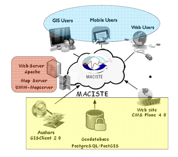
MArine Coastal Information SysTEm
(MACISTE ©)
|
System Description
The system is substantially an ASP (Application Service Provider); the software and data configuration and the functions are installed on a remote computer and managed directly by a technician (the client does not need to install the entire system in his computer). The user can access the information using an interface developed according to Internet page canons:
- Internet address
- Log-in
- Password
and utilise the software instruments to which he has acquired the rights.
The proposed system is easy to use, also when using particularly complex GIS with powerful analytical instruments.

The system is based on the most advanced technological solutions, and planned and developed using Open Source ware (software released with an open licence) to provide a glitch-free program that can be integrated with traditional information technology. The system provides a Geo Database that can manage map and alphanumeric information distributed via Internet thanks to a Web Map Server and Web applications with the following technology:
- RDBMS PostgreSQL with PostGIS spatial extension; PostgreSQL is a complete object-relational database with Open Source licence (BSD). PostgreSQL is a good alternative to other Open Source products such as MySQL, Firebird SQL and MaxDB and proprietary software such as Oracle, Informix and DB2, offering very advanced characteristics in the database sector.
- Cartographic Server UMN Map Server; Map Server is the Open Source environment for the development of spatial applications on a Web platform. It was originally developed by TerraSIP, a project sponsored by NASA, the University of Minnesota (UMN) and a consortium of companies interested in land management and is one of the most-used cartographic servers in the world, as is demonstrated by the extensive list available on its official site, with extensive applications. Even in Italy it is seen as one of the most competitive solutions by public authorities and private companies.
- Cartographic Client GISClient, created by Gis & Web S.r.l.
- Database sampling management application developed using Framework PraticaWeb.
The reference operative system is Linux with the Web Server Apache, but it has been tested using Windows with Web Server IIS infrastructures.
|


